The Ultimate Guide to Exploring the Narrow Canals of Kuttanad

Ask a local where the “real” Kerala backwaters are, and the answer is almost always Kuttanad. This low-lying delta south and east of Alleppey is a maze of rivers, lakes and narrow canals, wrapped around some of the most extraordinary farmland on earth: rice paddies that lie below sea level.
This guide covers what makes Kuttanad unique, how to explore its canals, the best routes and seasons, and the small details that turn a boat ride into a memorable day.
What Is Kuttanad?
Kuttanad is often called the Rice Bowl of Kerala. Four major rivers (the Pamba, Meenachil, Achankovil and Manimala) drain into Vembanad Lake here, creating a vast wetland. Over the last two centuries, farmers reclaimed huge areas of this wetland by building earthen bunds and pumping out the water, creating polders known locally as padasekharams and, for the largest lake reclamations, kayal lands.
The result is a landscape where:
- Paddy fields lie one to two metres below the water level of the canals beside them
- Villages sit on thin strips of land between fields and canals
- Water is the main highway, and many homes are reached only by boat
The UN’s Food and Agriculture Organization recognises the Kuttanad Below Sea Level Farming System as a Globally Important Agricultural Heritage System, one of very few in India.

Why the Narrow Canals Matter
Most visitors see Kuttanad from a houseboat on the wide lake channels. That is like seeing Venice only from the Grand Canal. The character of Kuttanad is in the narrow side canals, often just three to five metres wide, where:
- Homes, small shops and temples open directly onto the water
- Families wash clothes and dishes on stone steps (kadavu)
- Children row to school and fishermen work from coracles and canoes
- Kingfishers and herons hunt from overhanging branches
- You can look down on paddy fields from the canal
Only small boats can get in: shikaras, canoes and kayaks.
Explore the Narrow Canals by ShikaraHow to Explore Kuttanad’s Canals
By shikara (recommended)
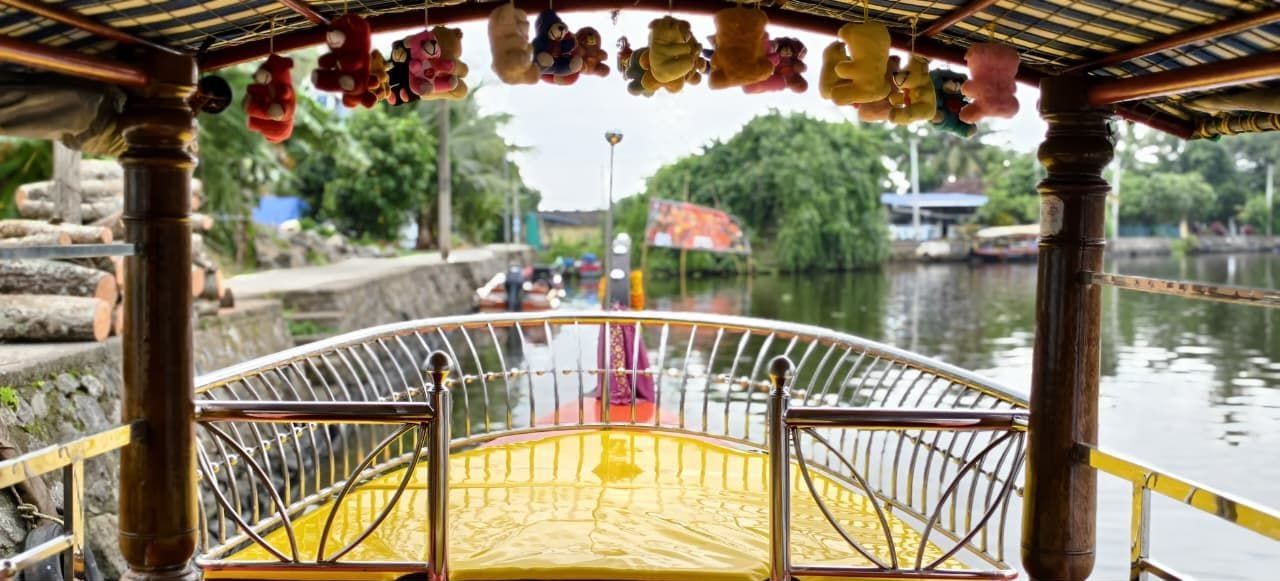
A shikara ride gives you the access of a small boat with the comfort of a canopy and cushioned seats. A local boatman knows which canals are open, where the water is deep enough and where to stop for tea or a toddy shop lunch. Three hours covers a good loop.
By kayak
Kayaks reach the very narrowest waterways and give you a slow, silent, eye-level view. They are best in the early morning or late afternoon. Our Shikara + Kayaking combo gives you both.
By canoe
Traditional dugout or plank canoes, paddled by a local, are the most authentic way to travel. They are slow and quiet but have little shade, so they’re best for short trips.
By public ferry
The State Water Transport Department runs public ferries between Alleppey and Kottayam and to villages across Kuttanad. These are a cheap, local experience, but they follow the main channels and run on fixed timetables.
By houseboat
Comfortable and great for an overnight stay, but houseboats cannot enter the narrow canals. See our houseboat vs. shikara comparison.
Best Routes Through Kuttanad
Routes vary with water levels, bridge heights and the farming season, so your boatman will adjust on the day. These are the stretches we use most.
1. Punnamada to the village canals
Starting at the Punnamada / Finishing Point jetty, boats cross the lake and turn into the canals of the villages on its far side. This is the classic first-timer’s loop, with plenty of village life and quick access to paddy fields.
2. Panackal Canal
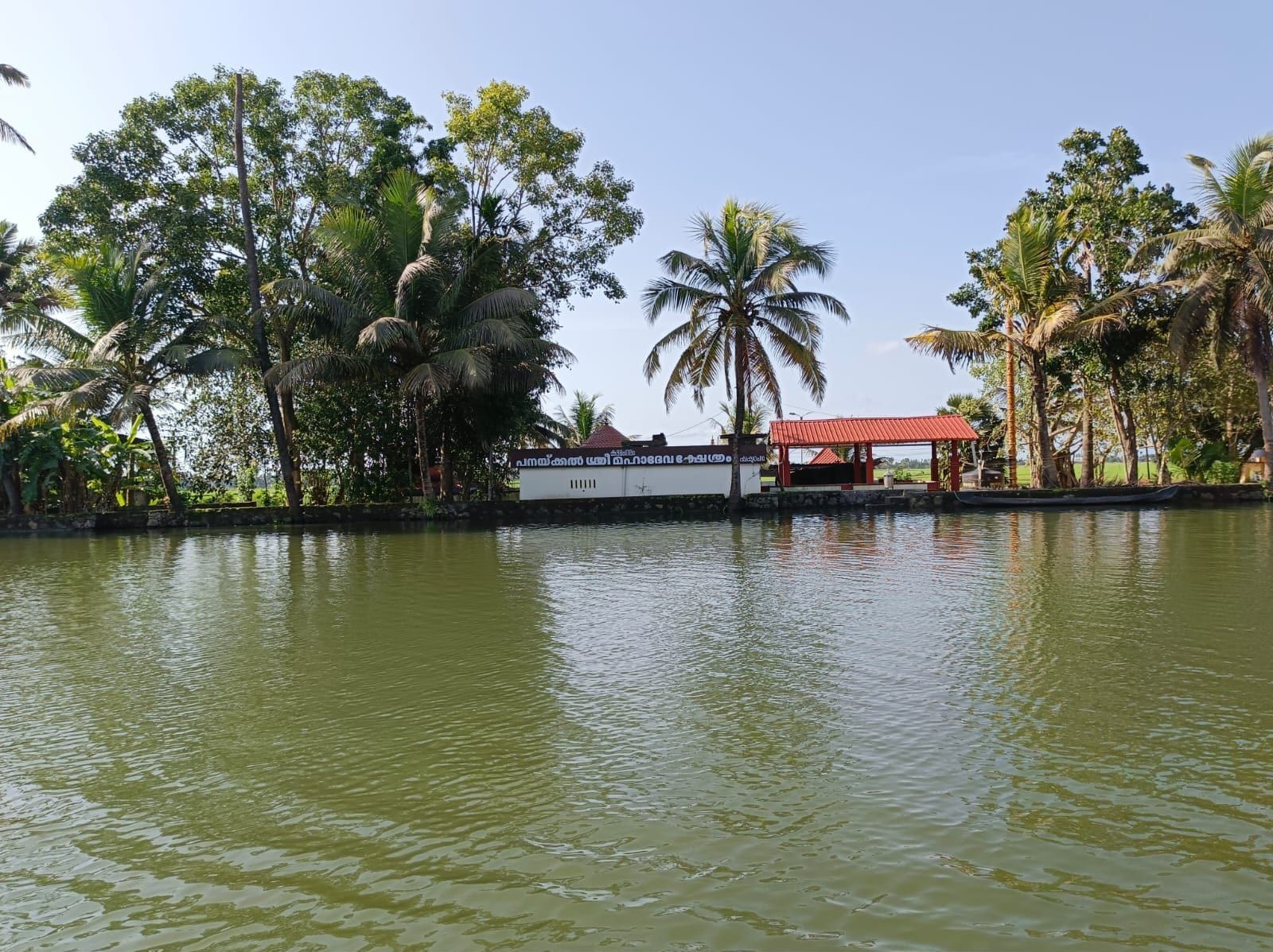
A beautiful palm-shaded canal that passes the riverside Panackal Sree Mahadeva Temple. It is part of our lunch cruise, with toddy shops along the way.
3. The reclaimed kayal lands
Further out, the great reclaimed polders of Kuttanad form vast, flat fields enclosed by bunds, with canals running along their edges at a higher level than the fields themselves. This is the best place to understand “below sea level” farming.
4. Vembanad Lake edge
Where the canals meet Vembanad Lake, the view suddenly opens to the horizon. It is a lovely contrast after the tight canals, and the best place for sunrise and sunset.

What You’ll See
Paddy fields below sea level
From the canal you will often look down onto the fields. Stop at a bund and walk along it: canal water on one side, and on the other, rice growing lower than the water beside you.
Village life
Coir workers, duck herders guiding hundreds of ducks down the canal, toddy tappers climbing coconut palms, small churches and temples, and canal-side tea shops serving chaya and banana fritters.

Birdlife
Common sightings include little and intermediate egrets, pond herons, purple herons, little cormorants, darters (snakebirds), white-throated and pied kingfishers, and brahminy kites. Early morning is best. Book the sunrise cruise.
Best Time to Explore Kuttanad
| Season | Months | What to expect |
|---|---|---|
| Post-monsoon & winter | Oct – Feb | Pleasant weather, green fields, migratory birds. Peak season. |
| Summer | Mar – May | Hot. Harvest time in many polders. Best at sunrise or sunset. |
| Monsoon | Jun – Sep | Lush and dramatic, high water, fewer tourists, lower prices. The Nehru Trophy Boat Race is in August. |
Time of day: the canals are calmest and coolest from 6 to 9 AM and from 4 to 7 PM. Midday is good for a lunch cruise with a shady boat.
Photography Tips
- Shoot at dawn. Mist plus still water gives perfect reflections.
- Use the canal as a leading line, with palms framing both sides.
- Get low to show how the fields sit below the canal.
- Ask before photographing people. Most villagers are happy to say yes, and a smile goes a long way.
- Bring a zoom (or a phone with 3x or more) for kingfishers and herons.
Responsible Travel in Kuttanad
Kuttanad is a living landscape, not a theme park. Please:
- Carry your plastic back. Don’t throw anything into the water.
- Keep noise low in the village canals. People live here.
- Respect privacy at bathing and washing steps.
- Choose operators who use local boatmen and avoid overloading boats.
Plan Your Kuttanad Canal Trip
The easiest way to see the narrow canals is a 3-hour private shikara with a local boatman. Choose sunrise for birds and mist, lunch for a toddy shop meal, or sunset for golden hour. Staying in Kumarakom? See our Kumarakom boat ride. For more ideas, read the top 10 things to do in Alleppey & Kumarakom.
Check Live AvailabilityFrequently Asked Questions
Where is Kuttanad?
Kuttanad is the low-lying delta region south and east of Alleppey town, bordering Vembanad Lake and spread across Alappuzha, Kottayam and Pathanamthitta districts. Most of it is reachable within 15–45 minutes by boat from Alleppey.
Why is Kuttanad below sea level?
Much of Kuttanad was reclaimed from Vembanad Lake and its wetlands by building bunds and pumping water out. The resulting paddy polders lie roughly one to two metres below sea level, held dry by dykes and pumps.
What is the best boat to explore Kuttanad's canals?
A shikara is the best balance of comfort and access: it is small enough for narrow canals but has a canopy and cushioned seating. For the very narrowest waterways, a kayak or traditional canoe is ideal.
Can I explore Kuttanad on a houseboat?
Only partly. Houseboats travel the wide lakes and main channels and cannot enter the narrow village canals that make Kuttanad special.